
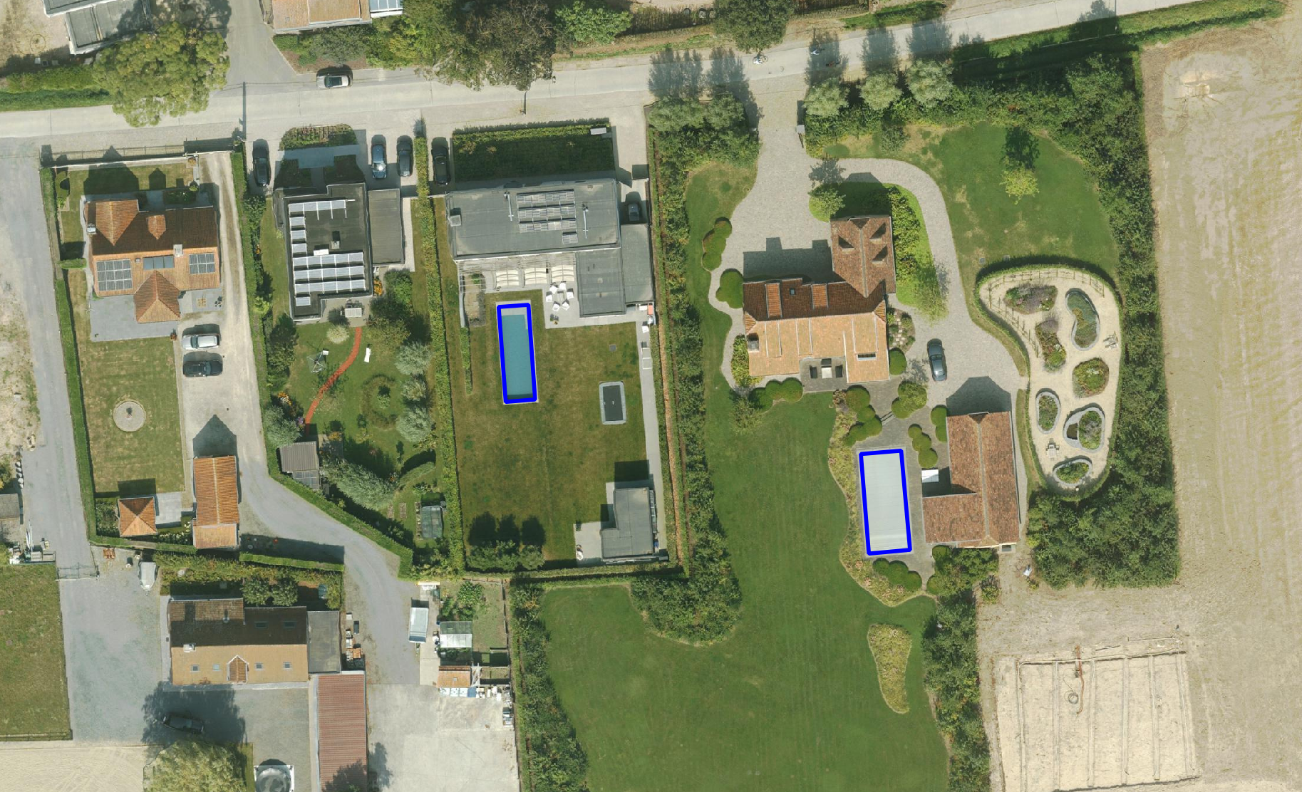
De inventarisatie van zwembaden wordt uitgevoerd op basis van onze true orthofoto's (GSD vanaf 3 cm), gecombineerd met AI-modellen die in samenwerking met KU Leuven (EAVISE) zijn ontwikkeld. Lees het volledig wetenschappelijk artikel over de samenwerking met KU Leuven.Het eindproduct is beschikbaar in twee varianten, namelijk op:Perceelsniveau: een shapefile waarin elk perceel (GRB - ADP) wordt aangeduid met een binaire waarde (zwembad: ja/nee)Objectniveau: een shapefile met individuele zwembaden, inclusief oppervlakteberekening per zwembad.De dataset kan worden geïntegreerd in elk GIS-platform of rechtstreeks worden gekoppeld aan de Plan3D Webviewer, zodat je eenvoudig kunt visualiseren, analyseren en combineren met andere lagen zoals gebouwen, percelen of verharding.
The swimming pool inventory is carried out based on our True Orthophotos (GSD from 3 cm), combined with AI models developed in collaboration with KU Leuven (EAVISE).
Read the full scientific article on the collaboration with KU Leuven.
The deliverable is available in two variants depending on the desired level of detail:
The dataset can be integrated into any GIS platform or linked directly to the Plan3D Webviewer, so you can easily visualise, analyse and combine it with other layers such as buildings, parcels or paved surfaces.
We deliver the data in ready-to-use GIS formats and the desired coordinate systems, fully checked for quality. Thanks to our standard data structure, the dataset integrates seamlessly into existing databases and workflows.
Our swimming pool inventory is AI-driven but always human-validated. Every delivery undergoes a thorough quality control process, ensuring a minimal margin of error and maximum reliability.


Our detection models were developed in collaboration with EAVISE (KU Leuven), a leading research group in visual AI. This guarantees innovative algorithms and reliable results. These Deep Learning algorithms automatically recognise swimming pools based on shape, colour, reflection and contextual features. After the automated detection, a thorough quality control is carried out by our specialists to minimise incorrect classifications. This gives us a reliability of over 95%.

We think along with your application and deliver the data in the form that best suits your needs. At parcel level the dataset is ideal for policy analyses, tax applications and permit management, while at object level detailed information is available for spatial planning, environmental studies and real estate analyses. We also hold historical datasets and carry out new captures every two years, allowing you to track developments over time, such as the growth of paved surfaces or trends in swimming pool installations.
The results can be integrated directly into dashboards, allowing automatic reports and statistics to be generated. For example, you can track the distribution of swimming pools, carry out trend analyses over time or visualise policy impacts at map level.
Our detection models were developed in collaboration with EAVISE (KU Leuven), a leading research group in visual AI. This guarantees innovative algorithms and reliable results. These Deep Learning algorithms automatically recognise swimming pools based on shape, colour, reflection and contextual features. After the automated detection, a thorough quality control is carried out by our specialists to minimise incorrect classifications. This gives us a reliability of over 95%.
We think along with your application and deliver the data in the form that best suits your needs. At parcel level the dataset is ideal for policy analyses, tax applications and permit management, while at object level detailed information is available for spatial planning, environmental studies and real estate analyses. We also hold historical datasets and carry out new captures every two years, allowing you to track developments over time, such as the growth of paved surfaces or trends in swimming pool installations.
The results can be integrated directly into dashboards, allowing automatic reports and statistics to be generated. For example, you can track the distribution of swimming pools, carry out trend analyses over time or visualise policy impacts at map level.

By 2040, Flanders must be asbestos-safe. Our aerial imagery and Deep Learning flag which roofs are suspected per address, so we can work together efficiently towards a healthier and safer living environment.
read more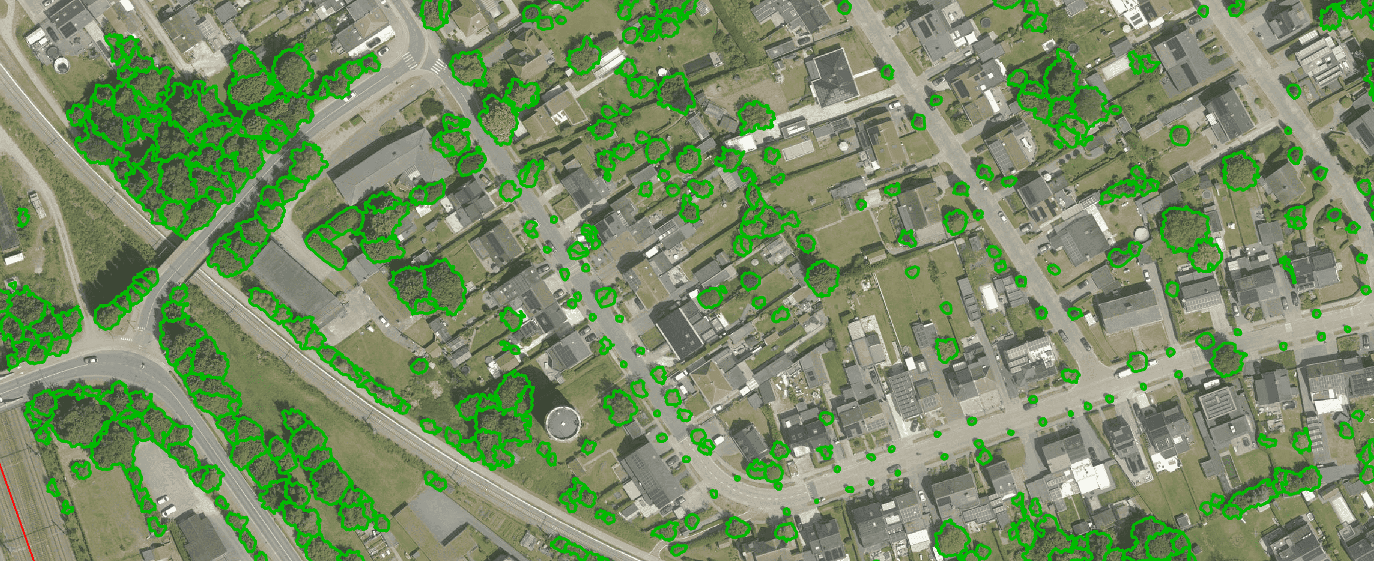
Get a complete overview of trees in your area, including individual characteristics such as crown area and height, and use the data to apply the European 3-30-300 rule for optimal urban greening. Ideal for municipalities, planners and green space managers who need accurate, scalable and policy-relevant geospatial data
read more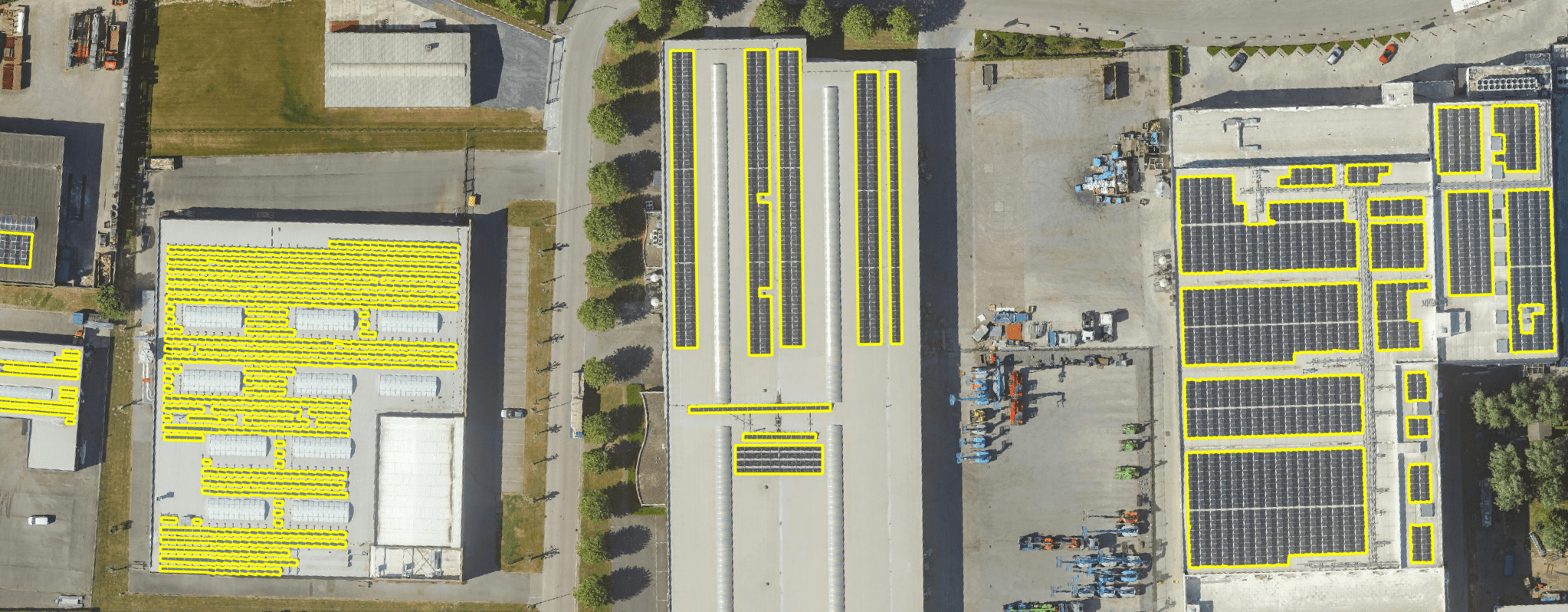
Get a detailed map layer of solar panels at building or cluster level, including surface area calculations per cluster. Ideal for anyone working with geospatial data who wants insight into energy potential and roof utilisation.
read more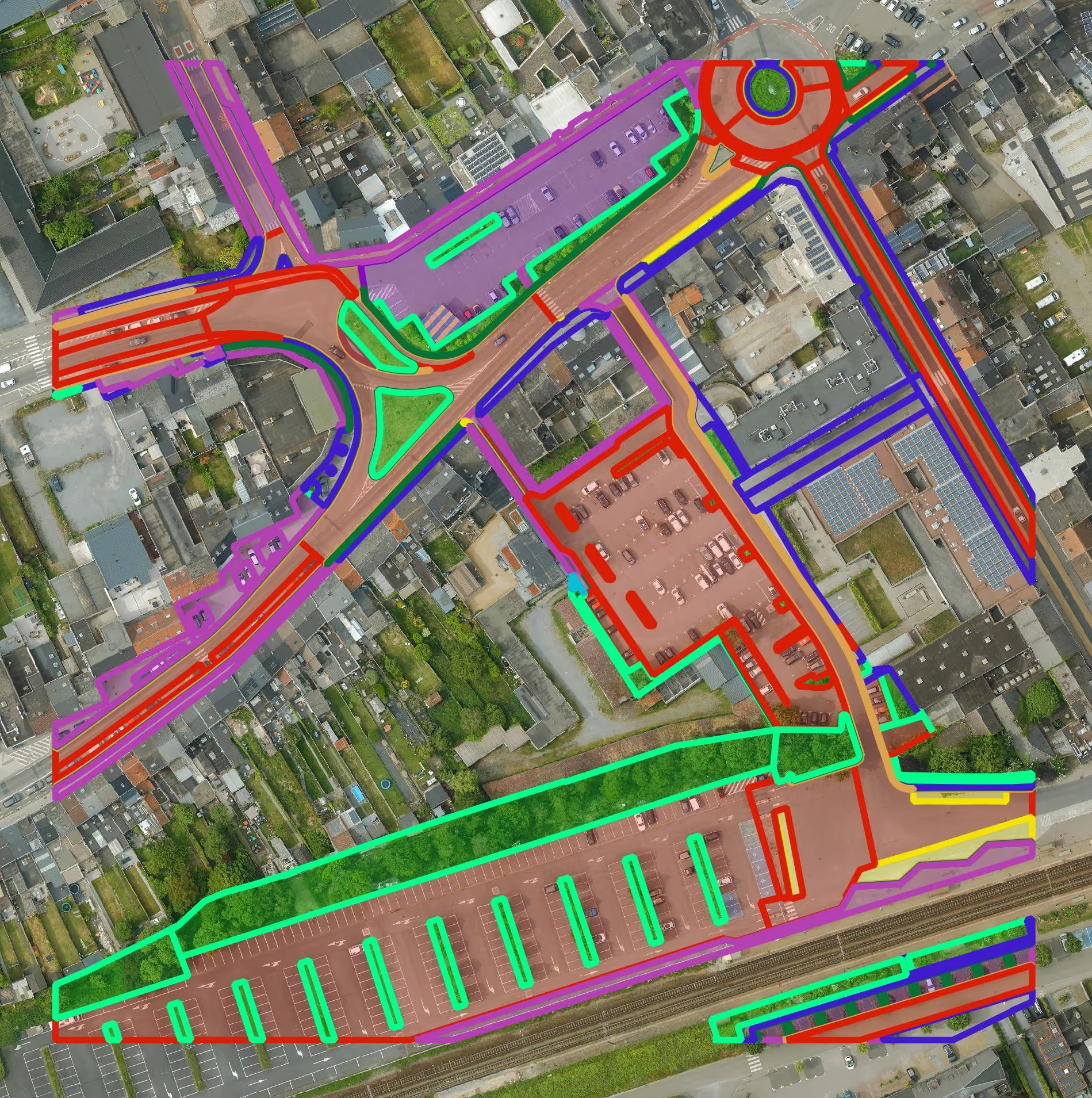
Get a detailed map layer of the public space with classification by object and material. Ideal for anyone working with geospatial data who needs more detail than existing reference data provides.
read more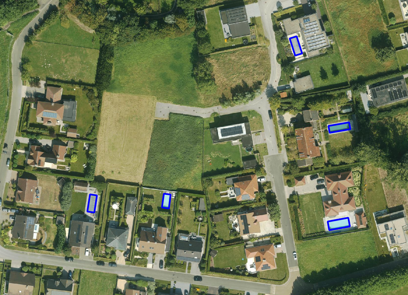
Get a detailed map layer of swimming pools at parcel or object level, including surface area calculations. Ideal for anyone using geospatial data for policy analysis, permits or trend research.
read more
Get a complete inventory of all road markings within your project area, classified into objects, lines and surfaces and linked to the correct underlying surface. This gives you objective data to support maintenance planning, reporting and policy decisions around mobility and asset management.
read more
Our paved/unpaved surface maps provide a complete and objective overview of where the ground is paved or unpaved, in both private and public space.
read moreEvery possible element of a cemetery is mapped. The result is a clear and organised plan that supports efficient and transparent cemetery management.
read more
Do you need a specific inventory that is not yet in our offering? We develop custom inventories tailored to your project. Thanks to our experience with aerial imagery and Deep Learning, we can detect and map almost any object type. Get in touch to discuss the possibilities.
Get in touchBy 2040, Flanders must be asbestos-safe. Our aerial imagery and Deep Learning flag which roofs are suspected per address, so we can work together efficiently towards a healthier and safer living environment.
read moreGet a complete overview of trees in your area, including individual characteristics such as crown area and height, and use the data to apply the European 3-30-300 rule for optimal urban greening. Ideal for municipalities, planners and green space managers who need accurate, scalable and policy-relevant geospatial data.
read moreGet a detailed map layer of solar panels at building or cluster level, including surface area calculations per cluster. Ideal for anyone working with geospatial data who wants insight into energy potential and roof utilisation.
read more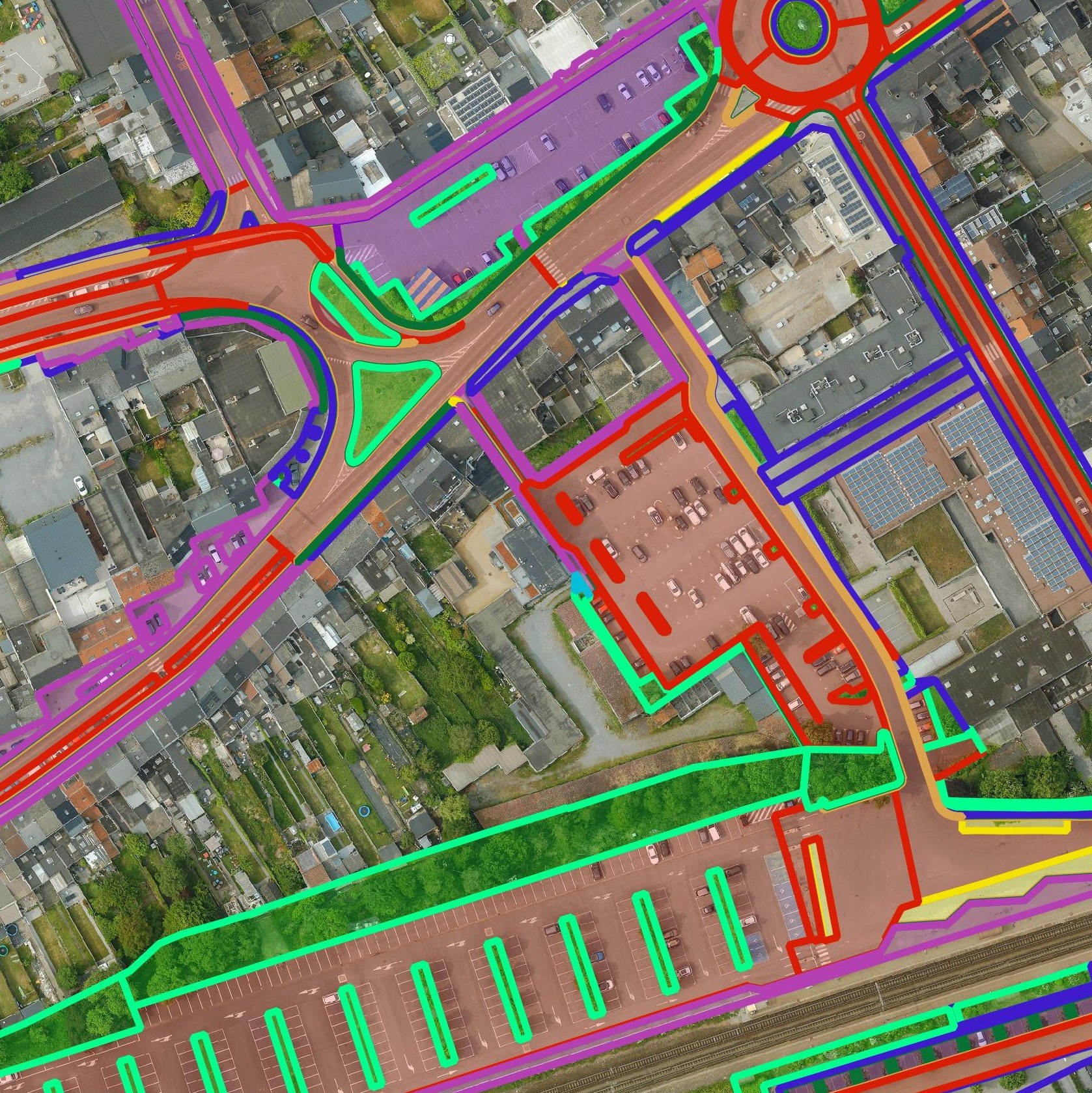
Get a detailed map layer of the public space with classification by object and material. Ideal for anyone working with geospatial data who needs more detail than existing reference data provides.
read moreGet a detailed map layer of swimming pools at parcel or object level, including surface area calculations. Ideal for anyone using geospatial data for policy analysis, permits or trend research.
read moreGet a complete inventory of all road markings within your project area, classified into objects, lines and surfaces and linked to the correct underlying surface. This gives you objective data to support maintenance planning, reporting and policy decisions around mobility and asset management.
read moreOur pavement surface maps provide a complete and objective overview of where the ground is paved or unpaved, in both private and public space.
read moreEvery possible element of a cemetery is mapped. The result is a clear and organised plan that supports efficient and transparent cemetery management.
read moreDo you need a specific inventory that is not yet in our offering? We develop custom inventories tailored to your project. Thanks to our experience with aerial imagery and Deep Learning, we can detect and map almost any object type. Get in touch to discuss the possibilities.
Get in touch
Gain insight into existing swimming pools within the municipality, support permit policy and regulatory compliance.

Use the data to better estimate water consumption or infiltration capacity, and evaluate the impact on flood-prone zones.

Link swimming pool data to real estate valuation, energy management or spatial analyses to better understand trends and developments in impervious surfaces and land use.
Gain insight into existing swimming pools within the municipality, support permit policy and regulatory compliance.
Use the data to better estimate water consumption or infiltration capacity, and evaluate the impact on flood-prone zones.
Link swimming pool data to real estate valuation, energy management or spatial analyses to better understand trends and developments in impervious surfaces and land use.

