With our Big Data layer you get a fully enriched view of the built environment. We combine our own LiDAR aerial surveys (>30 pts/m²) with official map layers such as GRB (Large-Scale Reference Database), PICC (Wallonia) and URBIS (Brussels), supplemented with AI detections and external data sources. In collaboration with KU Leuven (EAVISE) we developed advanced Deep Learning Object Detection algorithms that automatically recognise solar panels, asbestos roofs and swimming pools with an accuracy above 95%. We also perform 3D calculations based on our LiDAR data, such as surface areas, volumes and heights per building. All information is fully integrated in the Plan3D Webviewer and easy to combine with other layers, without additional software. We continue to expand our Big Data layer, with the next step being the automatic detection and classification of roof components. The Big Data layer is part of our Extra Plan3D services, but is also available separately.
With our Big Data layer you get a fully enriched view of the built environment. We combine our own LiDAR aerial surveys (>30 pts/m²) with official map layers such as GRB (Large-Scale Reference Database), PICC (Wallonia) and URBIS (Brussels), supplemented with AI detections and external data sources.
In collaboration with KU Leuven (EAVISE) we developed advanced Deep Learning Object Detection algorithms. These automatically recognise solar panels, asbestos roofs and swimming pools with an accuracy above 95%. Read the full scientific article.
All information is fully integrated in the Plan3D Webviewer and easy to combine with other layers, without additional software. We continue to expand our Big Data layer, with the next step being the automatic detection and classification of roof components. The Big Data layer is part of our Extra Plan3D services, but is also available separately.
This advanced data is activated via your Plan3D license or physically delivered in common GIS formats such as GeoPackage, Shapefile, KML or GeoJSON. This Big Data dataset is available for complete regions or specific zones. The dataset includes building, parcel, facade and terrain data.
We always deliver our Big Data in the agreed formats with fixed quality controls, and according to a schedule that is clearly agreed in advance so you always know when the data will be available.


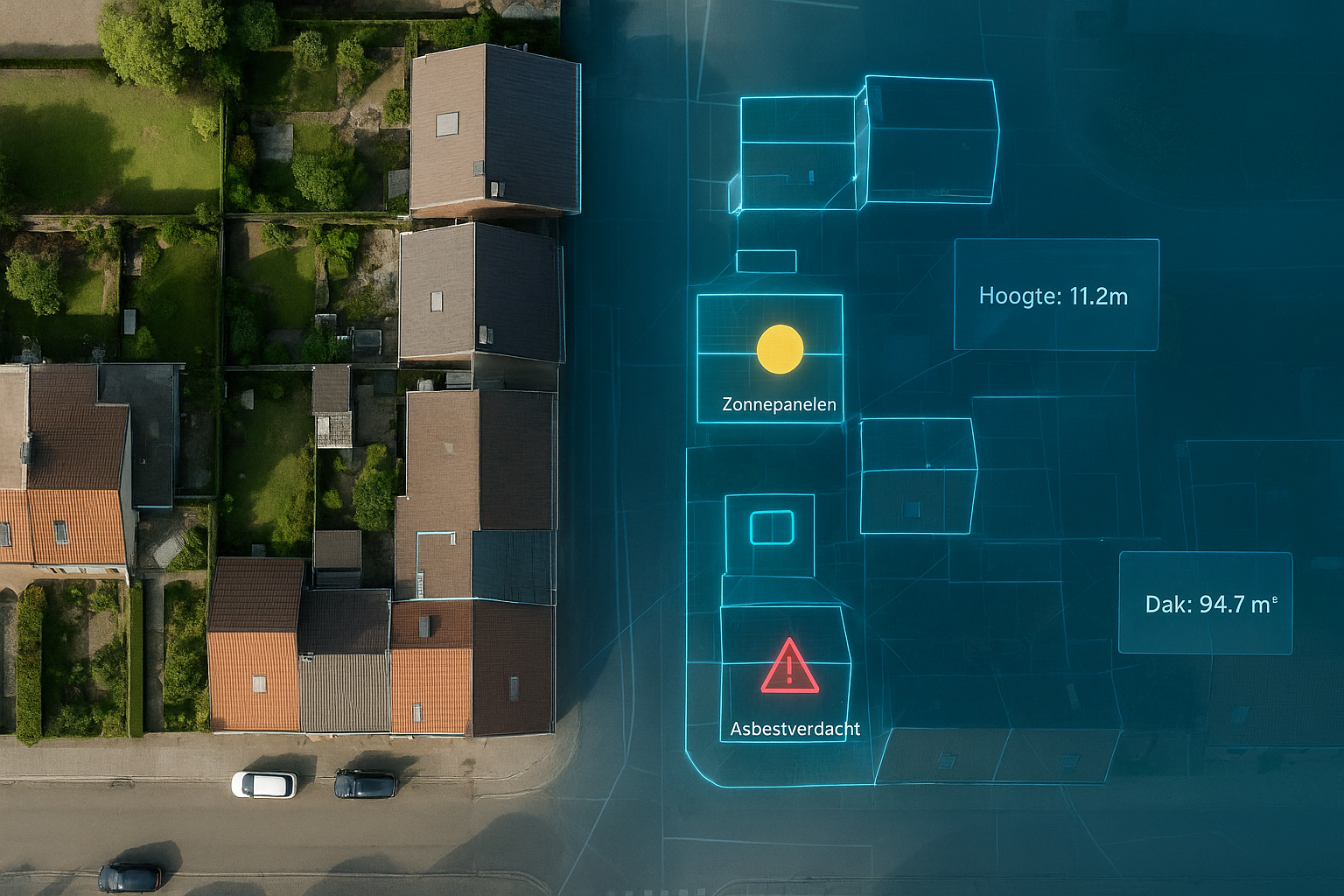
In collaboration with KU Leuven (EAVISE) we apply Deep Learning to automatically detect solar panels, asbestos roofs and other rooftop features based on our aerial imagery with a GSD from 3 cm and LiDAR Point Cloud data with a density from 30 pts/m². Our models achieve an accuracy above 95% and are continuously improved through quality controls. This means you always have access to current, validated information about the rooftops within your area.
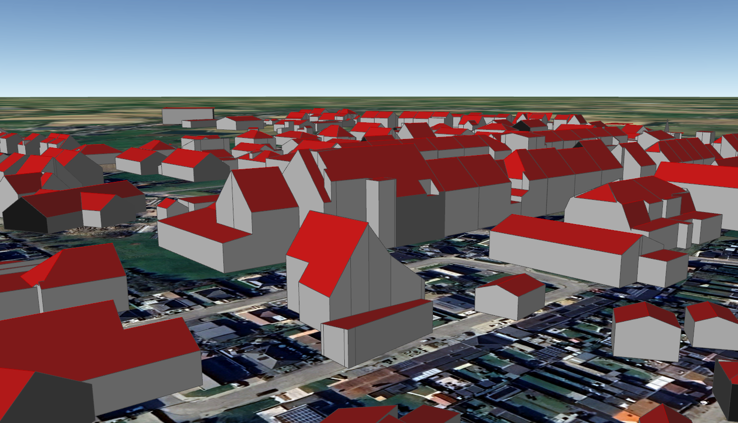
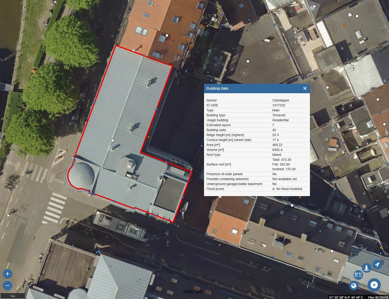
Our Big Data layer enriches every building with 3D data from our own LiDAR scans, converted into LOD200/LOD2 models. We automatically calculate ridge height, eaves height, volume, surface area, and estimated number of floors. This gives you reliable, fully georeferenced 3D data, ready for analysis, policy, and spatial planning.

Our complete dataset can be integrated into a dashboard, making it easy to visualise and analyse building statistics such as height, volume, and solar panel presence.
In collaboration with KU Leuven (EAVISE) we apply Deep Learning to automatically detect solar panels, asbestos roofs and other rooftop features based on our aerial imagery with a GSD from 3 cm and LiDAR Point Cloud data with a density from 30 pts/m². Our models achieve an accuracy above 95% and are continuously improved through quality controls. This means you always have access to current, validated information about the rooftops within your area.
Our Big Data layer enriches every building with 3D data from our own LiDAR scans, converted into LOD200/LOD2 models. We automatically calculate ridge height, eaves height, volume, surface area, and estimated number of floors. This gives you reliable, fully georeferenced 3D data, ready for analysis, policy, and spatial planning.
Our complete dataset can be integrated into a dashboard, making it easy to visualise and analyse building statistics such as height, volume, and solar panel presence.

By 2040, Flanders must be asbestos-safe. Our aerial imagery and Deep Learning flag which roofs are suspected per address, so we can work together efficiently towards a healthier and safer living environment.
read more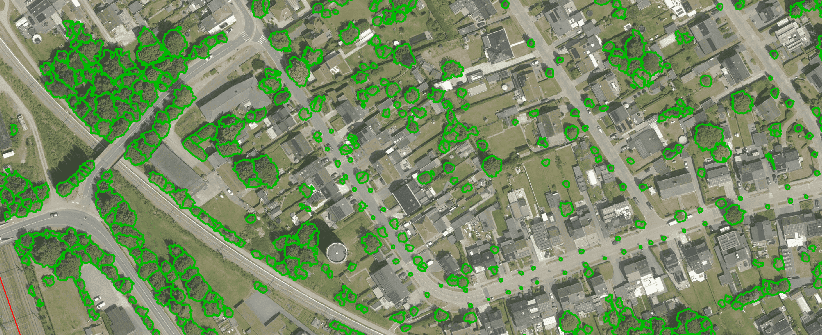
Get a complete overview of trees in your area, including individual characteristics such as crown area and height, and use the data to apply the European 3-30-300 rule for optimal urban greening. Ideal for municipalities, planners and green space managers who need accurate, scalable and policy-relevant geospatial data
read more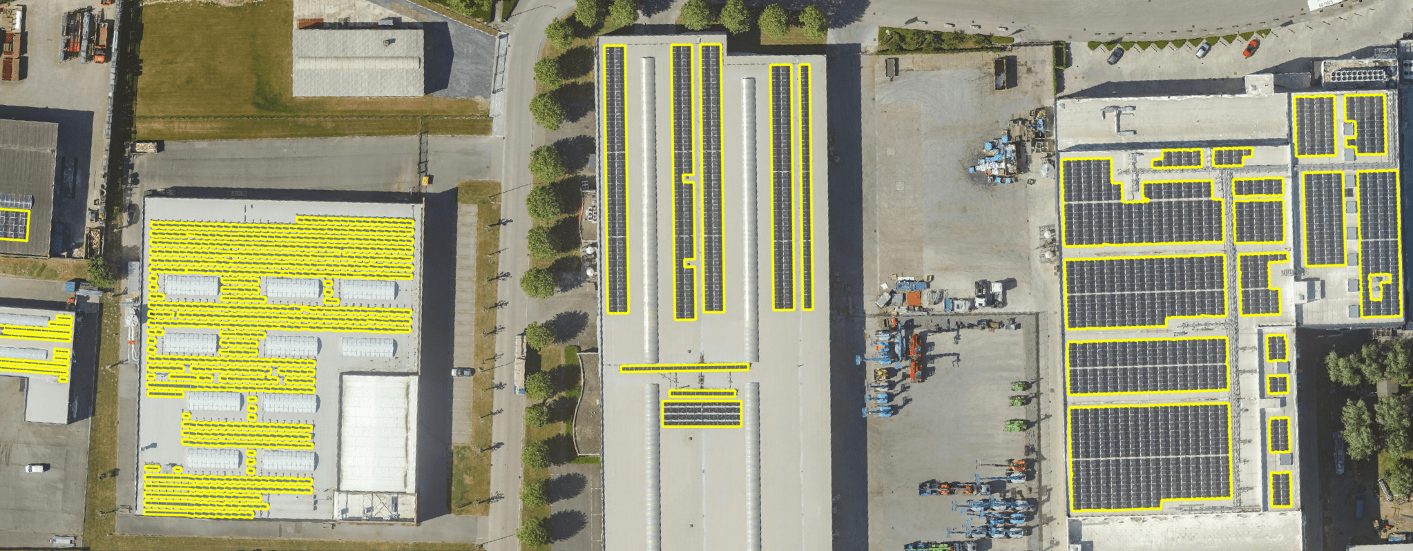
Get a detailed map layer of solar panels at building or cluster level, including surface area calculations per cluster. Ideal for anyone working with geospatial data who wants insight into energy potential and roof utilisation.
read more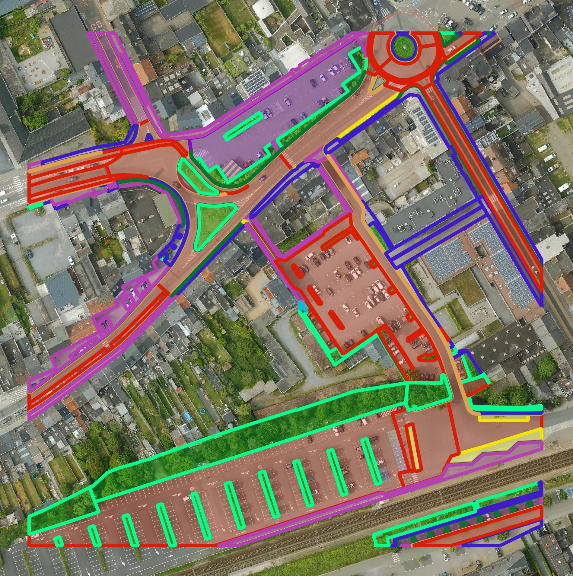
Get a detailed map layer of the public space with classification by object and material. Ideal for anyone working with geospatial data who needs more detail than existing reference data provides.
read more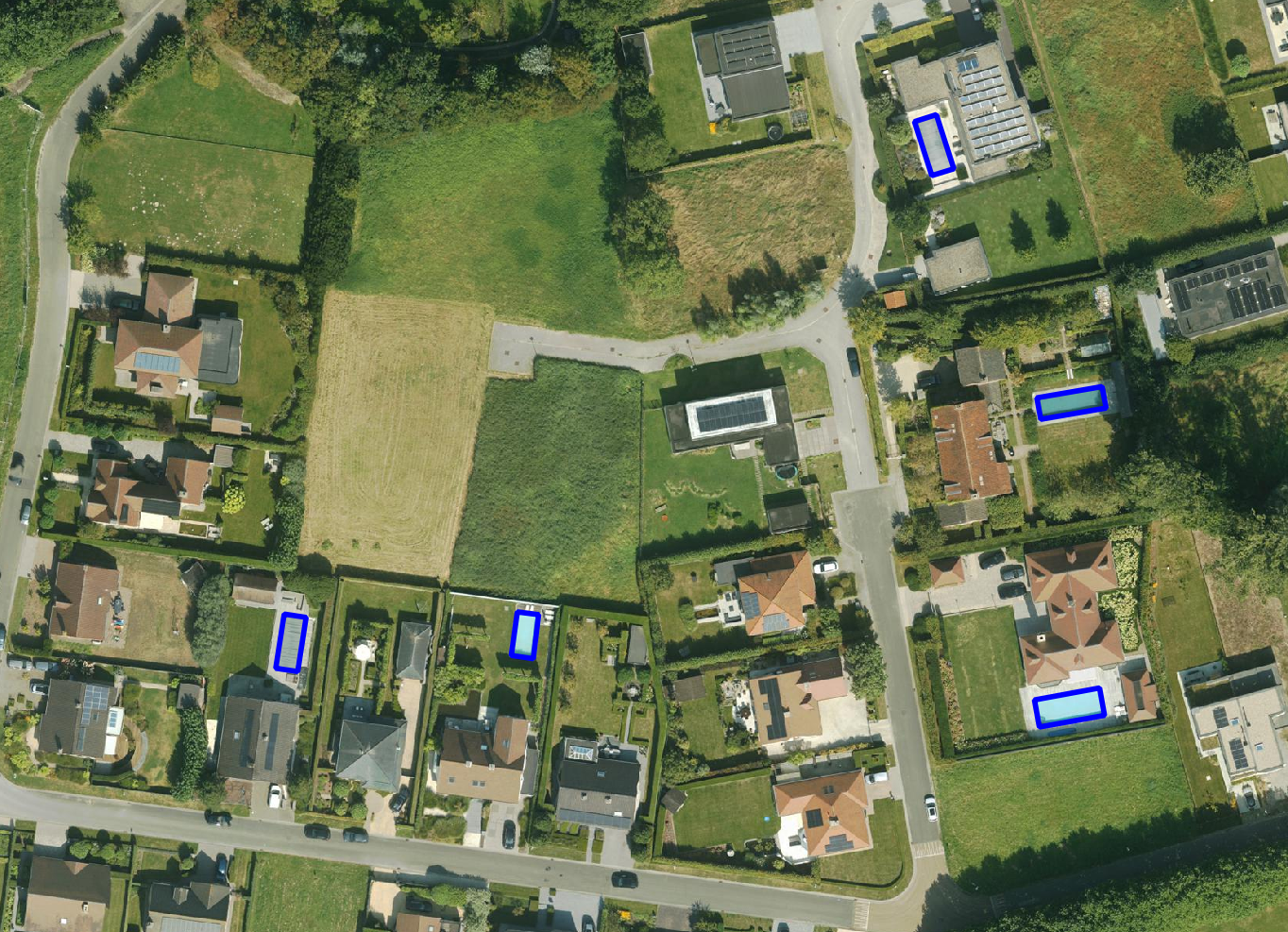
Get a detailed map layer of swimming pools at parcel or object level, including surface area calculations. Ideal for anyone using geospatial data for policy analysis, permits or trend research.
read more
Get a complete inventory of all road markings within your project area, classified into objects, lines and surfaces and linked to the correct underlying surface. This gives you objective data to support maintenance planning, reporting and policy decisions around mobility and asset management.
read more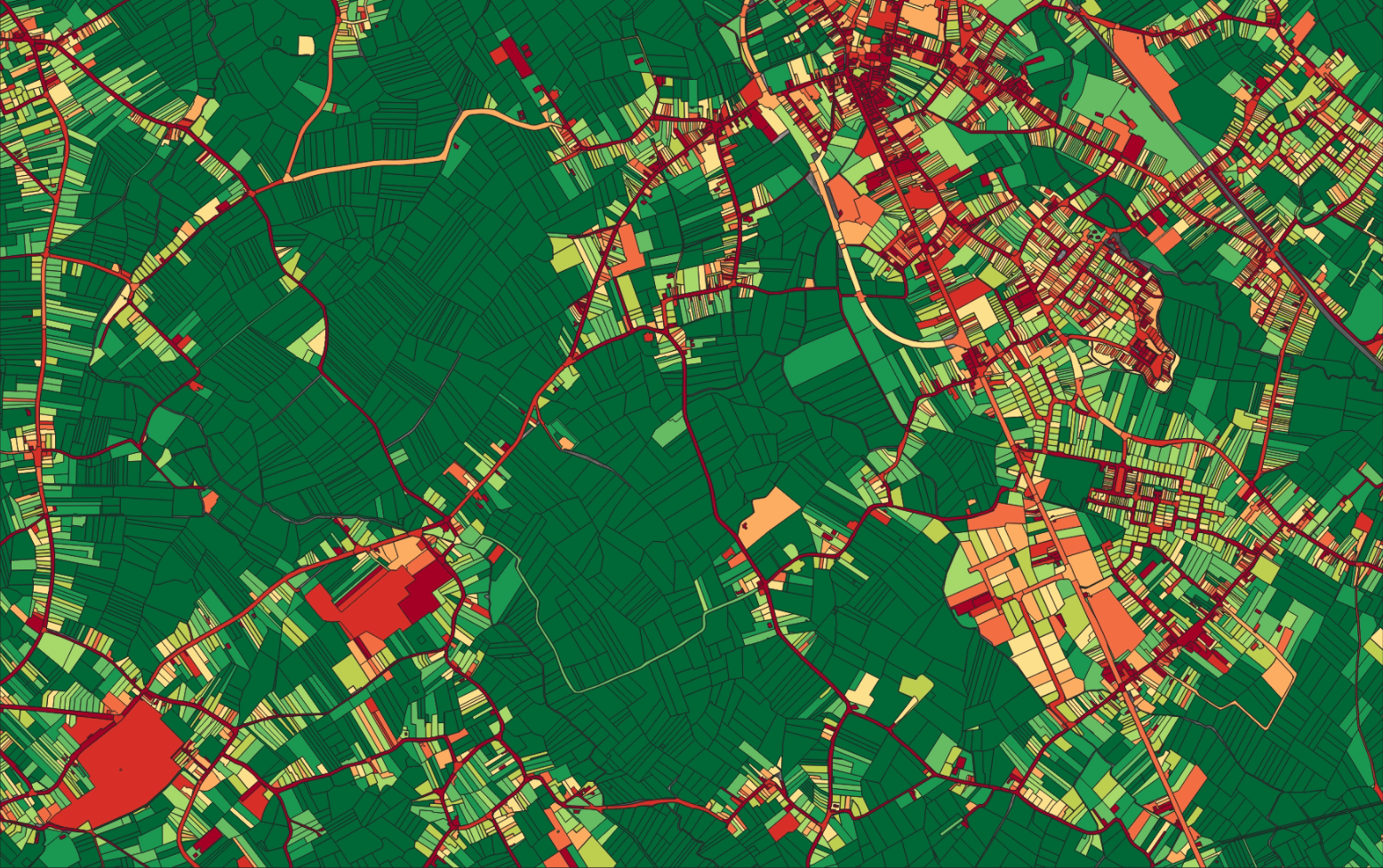
Our paved/unpaved surface maps provide a complete and objective overview of where the ground is paved or unpaved, in both private and public space.
read moreEvery possible element of a cemetery is mapped. The result is a clear and organised plan that supports efficient and transparent cemetery management.
read more
Do you need a specific inventory that is not yet in our offering? We develop custom inventories tailored to your project. Thanks to our experience with aerial imagery and Deep Learning, we can detect and map almost any object type. Get in touch to discuss the possibilities.
Get in touchBy 2040, Flanders must be asbestos-safe. Our aerial imagery and Deep Learning flag which roofs are suspected per address, so we can work together efficiently towards a healthier and safer living environment.
read moreGet a complete overview of trees in your area, including individual characteristics such as crown area and height, and use the data to apply the European 3-30-300 rule for optimal urban greening. Ideal for municipalities, planners and green space managers who need accurate, scalable and policy-relevant geospatial data.
read moreGet a detailed map layer of solar panels at building or cluster level, including surface area calculations per cluster. Ideal for anyone working with geospatial data who wants insight into energy potential and roof utilisation.
read more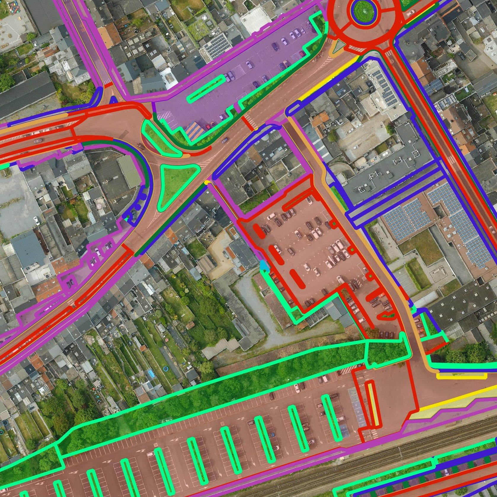
Get a detailed map layer of the public space with classification by object and material. Ideal for anyone working with geospatial data who needs more detail than existing reference data provides.
read moreGet a detailed map layer of swimming pools at parcel or object level, including surface area calculations. Ideal for anyone using geospatial data for policy analysis, permits or trend research.
read moreGet a complete inventory of all road markings within your project area, classified into objects, lines and surfaces and linked to the correct underlying surface. This gives you objective data to support maintenance planning, reporting and policy decisions around mobility and asset management.
read moreOur pavement surface maps provide a complete and objective overview of where the ground is paved or unpaved, in both private and public space.
read moreEvery possible element of a cemetery is mapped. The result is a clear and organised plan that supports efficient and transparent cemetery management.
read moreDo you need a specific inventory that is not yet in our offering? We develop custom inventories tailored to your project. Thanks to our experience with aerial imagery and Deep Learning, we can detect and map almost any object type. Get in touch to discuss the possibilities.
Get in touch
Monitor the building shift, land use and climate targets with one central database. Current and objective data are bundled on buildings, parcels, facades and terrains.

Use reliable data for asset management, capacity planning and risk assessment. Decisions are better supported and more efficiently executed.

Analyse building characteristics such as roof type, volume, surface area and risk materials for insurance purposes and market overview.
Monitor the building shift, land use and climate targets with one central database. Current and objective data are bundled on buildings, parcels, facades and terrains.
Use reliable data for asset management, capacity planning and risk assessment. Decisions are better supported and more efficiently executed.
Analyse building characteristics such as roof type, volume, surface area and risk materials for insurance purposes and market overview.

