Met onze inventariskaarten beschik je over een uitgebreid overzicht van zowel natuurlijke als gebouwde elementen, verrijkt met informatie over risico’s en eigenschappen. Deze kaarten zijn gebaseerd op onze hoogwaardige luchtbeelden met een GSD vanaf 3 cm, LiDAR-data met een densiteit vanaf 30 pts/m² en terrestrische metingen, uitgevoerd door ons landmetersteam. Ze worden aangevuld met geautomatiseerde detecties en kwaliteitscontroles, zodat je altijd betrouwbare data ontvangt. Daarnaast kunnen we op maat gemaakte digitale datasets leveren, volledig afgestemd op jouw specifieke behoeften. Zo kun je de inventarisdata koppelen aan een GIS-systeem, analyseren in dashboards of combineren met andere Plan3D-lagen zoals 3D-meshes of Big Data. Bij het scrollen naar beneden vind je alle standaardinventarissen die we aanbieden. Bovendien beschikken we over historische datasets, zodat je meerdere jaargangen kunt bestellen en veranderingen over de tijd kunt visualiseren en meten via dashboards.
With our inventories you have a comprehensive overview of both natural and built elements, enriched with information on risks and characteristics. These maps are based on our high-quality aerial imagery with a GSD from 3 cm, LiDAR Point Cloud data with a density from 30 pts/m² and terrestrial measurements carried out by our surveying team. They are supplemented with automated detections and quality controls, so you always receive reliable data. In addition, we can deliver custom digital datasets, fully tailored to your specific needs. This allows you to link the inventory data to a GIS system, analyse it in dashboards or combine it with other Plan3D layers such as 3D Meshes or Big Data.
Scrolling down you will find all the standard inventories we offer. We also hold historical datasets, so you can order multiple years and visualise and measure changes over time via dashboards.
We deliver via FTP, in common GIS formats and coordinate systems. All datasets are thoroughly checked and ready to use directly in your own GIS environment or linkable to the Plan3D Webviewer. Delivery takes place as agreed, with transparent communication on planning and progress. Periodic updates are possible when new aerial imagery or re-inventories become available.
We always deliver our data in the agreed formats, fully validated and immediately ready for use. We support you with integration into your GIS environment, with one dedicated point of contact for fast and personal support.


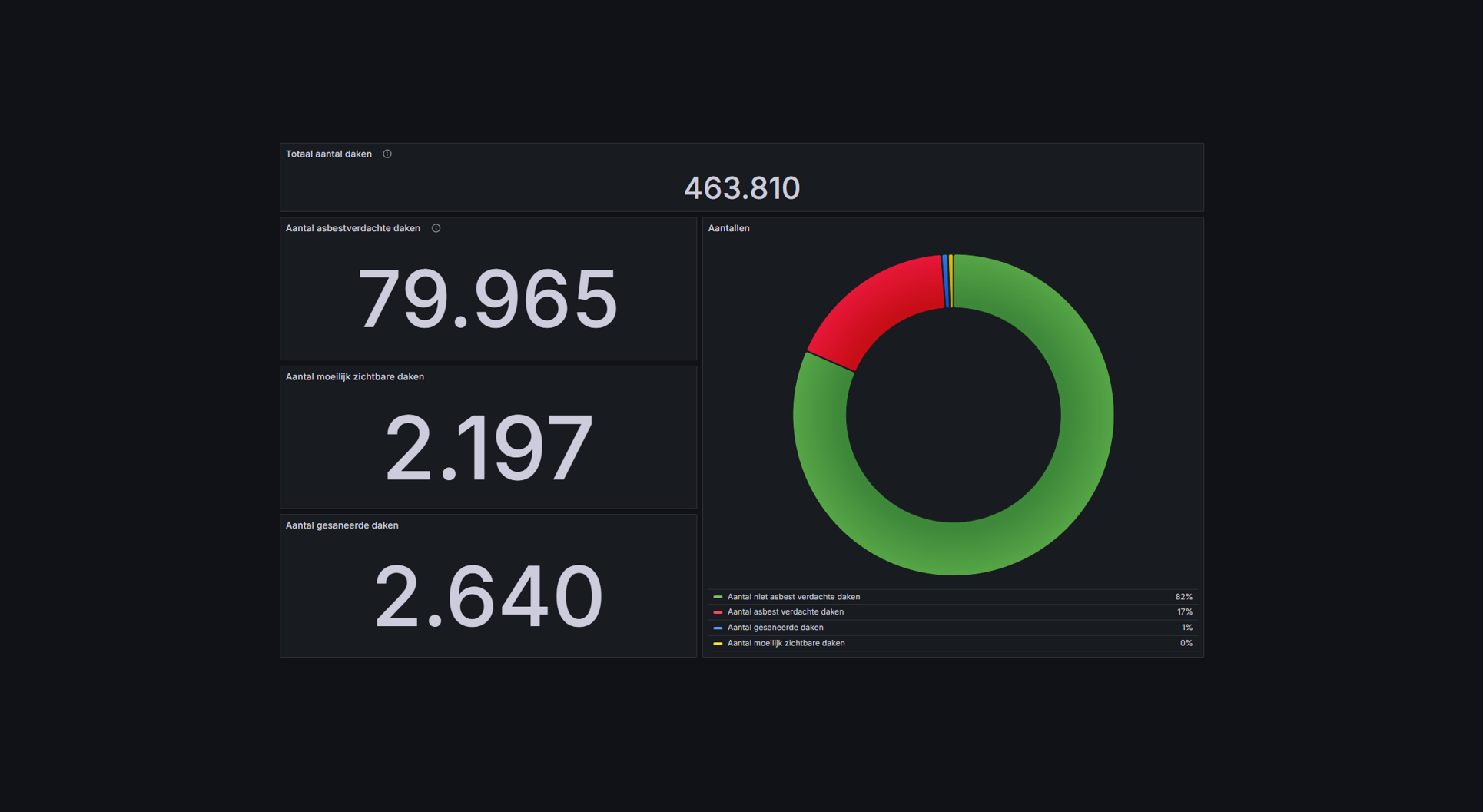
By 2040, Flanders must be asbestos-safe. Our aerial imagery and Deep Learning flag which roofs are suspected per address, so we can work together efficiently towards a healthier and safer living environment.
Get a complete inventory of all trees within your project area, including height, crown width and exact location. With this reliable data you can make well-founded decisions for green space management, urban planning and climate adaptation.
In collaboration with EAVISE (KU Leuven) we use Deep Learning to detect solar panel clusters on orthophotos and DEMs. This quickly gives us insight into which rooftops are already covered, what space is available for new panels and how many homes have solar panels.

By 2040, Flanders must be asbestos-safe. Our aerial imagery and Deep Learning flag which roofs are suspected per address, so we can work together efficiently towards a healthier and safer living environment.
read more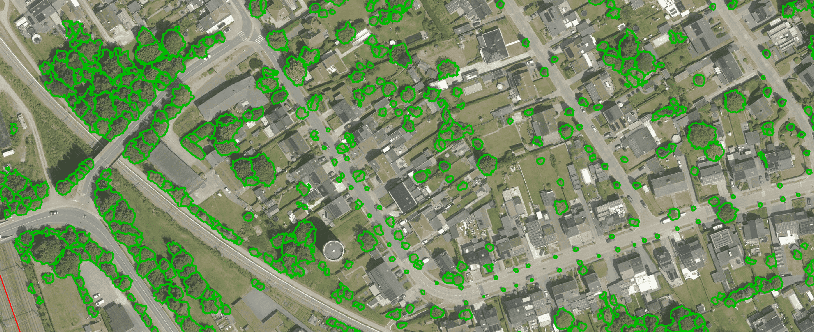
Get a complete overview of trees in your area, including individual characteristics such as crown area and height, and use the data to apply the European 3-30-300 rule for optimal urban greening. Ideal for municipalities, planners and green space managers who need accurate, scalable and policy-relevant geospatial data
read more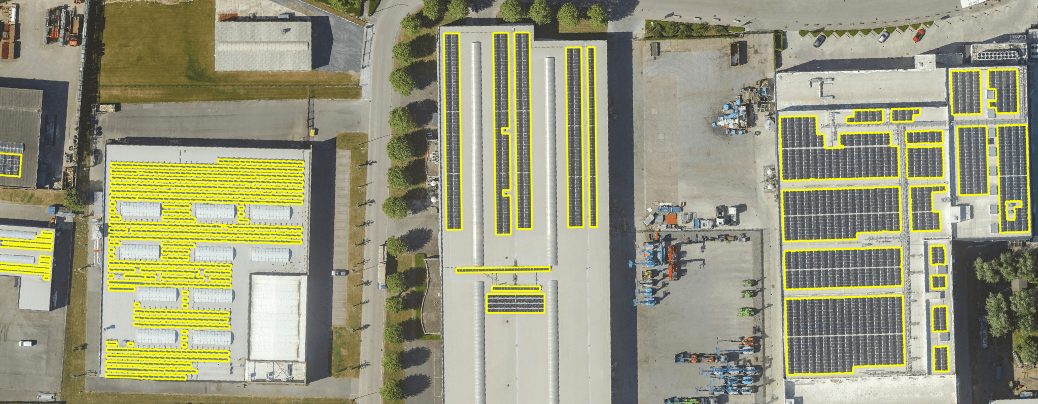
Get a detailed map layer of solar panels at building or cluster level, including surface area calculations per cluster. Ideal for anyone working with geospatial data who wants insight into energy potential and roof utilisation.
read more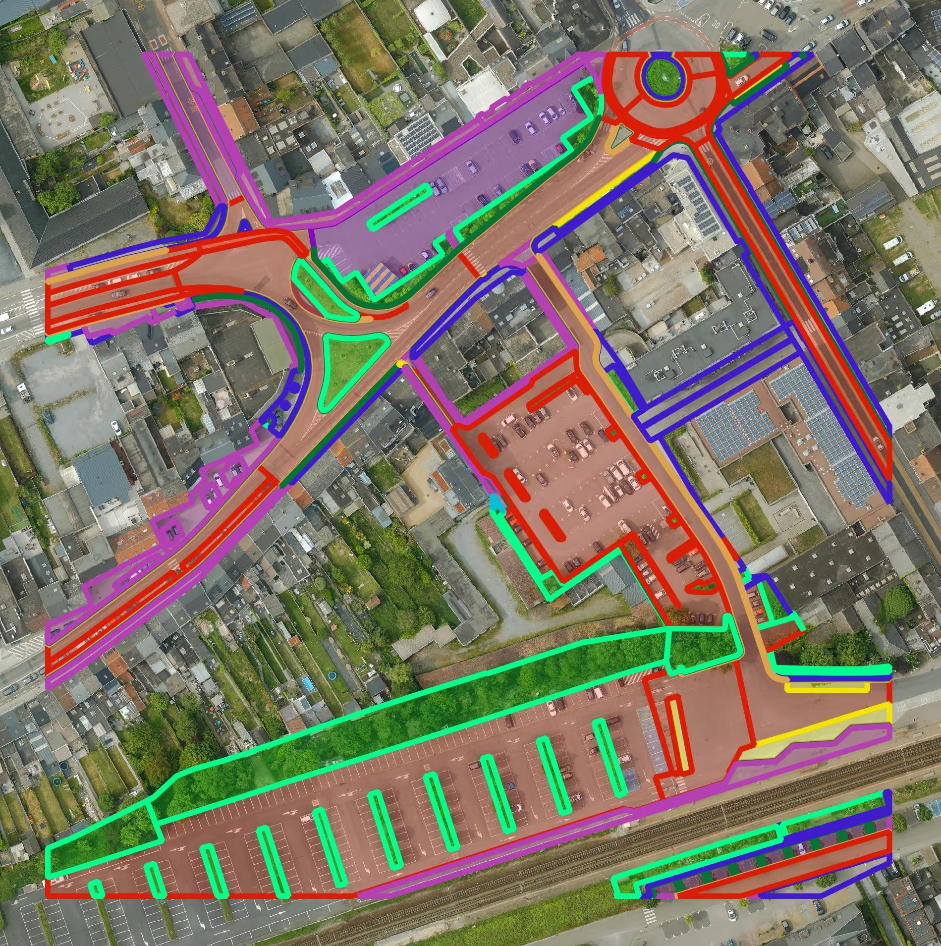
Get a detailed map layer of the public space with classification by object and material. Ideal for anyone working with geospatial data who needs more detail than existing reference data provides.
read more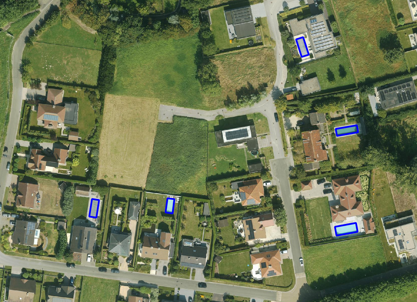
Get a detailed map layer of swimming pools at parcel or object level, including surface area calculations. Ideal for anyone using geospatial data for policy analysis, permits or trend research.
read more
Get a complete inventory of all road markings within your project area, classified into objects, lines and surfaces and linked to the correct underlying surface. This gives you objective data to support maintenance planning, reporting and policy decisions around mobility and asset management.
read more
Our paved/unpaved surface maps provide a complete and objective overview of where the ground is paved or unpaved, in both private and public space.
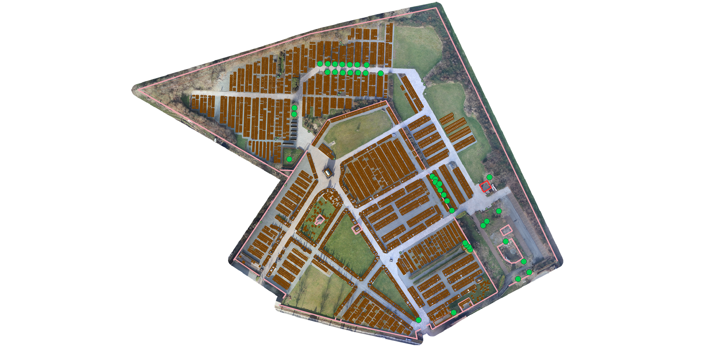
read moreEvery possible element of a cemetery is mapped. The result is a clear and organised plan that supports efficient and transparent cemetery management.
read more
Do you need a specific inventory that is not yet in our offering? We develop custom inventories tailored to your project. Thanks to our experience with aerial imagery and Deep Learning, we can detect and map almost any object type. Get in touch to discuss the possibilities.
Get in touchBy 2040, Flanders must be asbestos-safe. Our aerial imagery and Deep Learning flag which roofs are suspected per address, so we can work together efficiently towards a healthier and safer living environment.
read moreGet a complete overview of trees in your area, including individual characteristics such as crown area and height, and use the data to apply the European 3-30-300 rule for optimal urban greening. Ideal for municipalities, planners and green space managers who need accurate, scalable and policy-relevant geospatial data.
read moreGet a detailed map layer of solar panels at building or cluster level, including surface area calculations per cluster. Ideal for anyone working with geospatial data who wants insight into energy potential and roof utilisation.
read more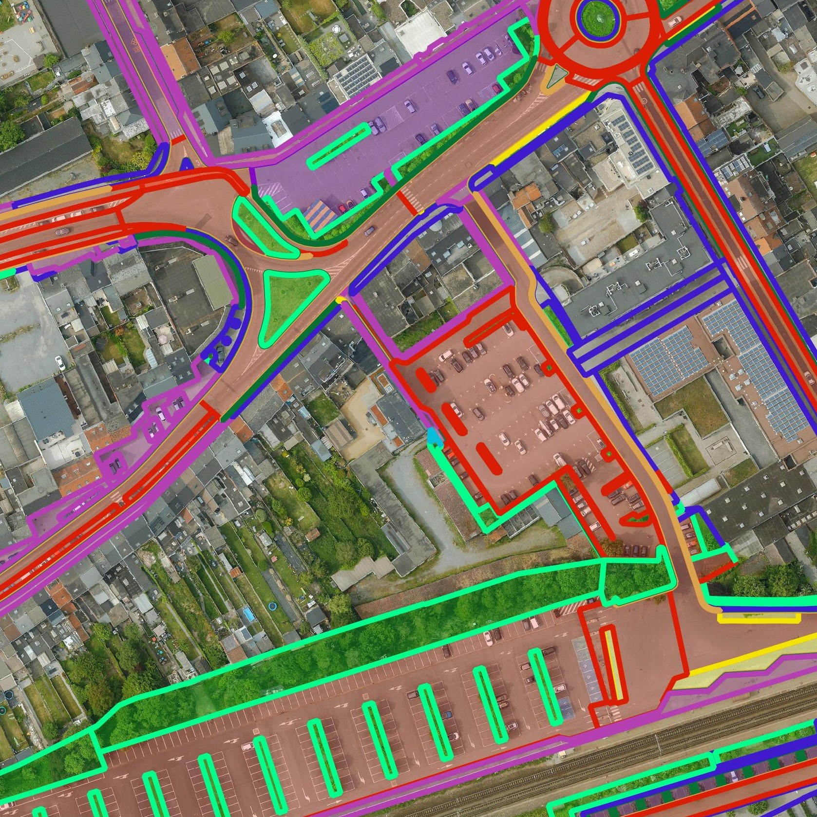
Get a detailed map layer of the public space with classification by object and material. Ideal for anyone working with geospatial data who needs more detail than existing reference data provides.
read moreGet a detailed map layer of swimming pools at parcel or object level, including surface area calculations. Ideal for anyone using geospatial data for policy analysis, permits or trend research.
read moreGet a complete inventory of all road markings within your project area, classified into objects, lines and surfaces and linked to the correct underlying surface. This gives you objective data to support maintenance planning, reporting and policy decisions around mobility and asset management.
read moreOur pavement surface maps provide a complete and objective overview of where the ground is paved or unpaved, in both private and public space.
read moreEvery possible element of a cemetery is mapped. The result is a clear and organised plan that supports efficient and transparent cemetery management.
read moreDo you need a specific inventory that is not yet in our offering? We develop custom inventories tailored to your project. Thanks to our experience with aerial imagery and Deep Learning, we can detect and map almost any object type. Get in touch to discuss the possibilities.
Get in touch
